Tutorial for NMEA GPS
What is NMEA GPS?
NMEA is an acronym for National Marine Electronics Association. All GPS manufacturers, including the cellular module vendors support the standard NMEA GPS data format. This data format enables application developers to use their GPS application across many different GPS devices.
What interfaces are supported for NMEA GPS?
NMEA GPS is supported across variety of interfaces such as USB, RS-232, Bluetooth, UHF, Bluetooth and others.
How is NMEA GPS supported on cellular modules?
In cellular modules that supports GPS feature, NMEA GPS data is generally made available through one of the serial ports. In addition to modem and diagnostics data port, modules that support GPS feature will make NMEA GPS data available through the NMEA port.
How to find the NMEA port in cellular Modules?
Once the manufacturer provided device drivers are installed on the host PC, the NMEA port can be located in the Device Manager.
Examples of locating NMEA Ports,
- Find NMEA port in Sierra Wireless Modules
- Find NMEA port in Simcom modules
NMEA ports in other cellular module manufactures can be similarly located after installing the Windows device drivers that is provided by the manufacturer.
How to read data from the NMEA port?
To read NMEA GPS data,
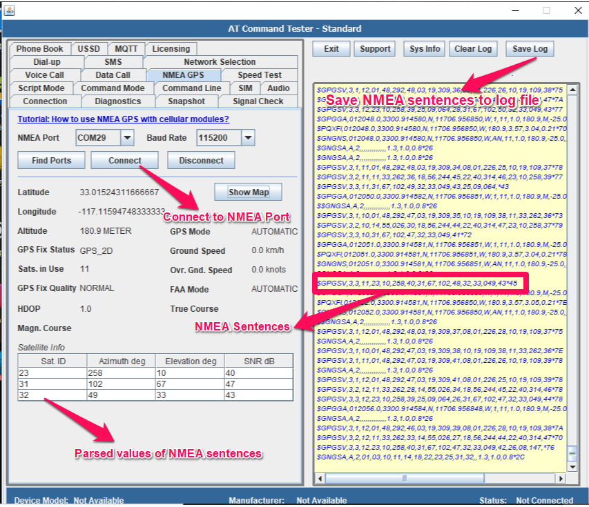
- Find an application such as AT Command Tester that can parse data from the NMEA port.
- Connect the GPS device over the interface that is supported by the device.
- Display NMEA GPS data read from the NMEA port.
Example of reading GPS data from NMEA port,
What is a NMEA sentence?
GPS devices transmit location information in NMEA standard. The ascii-formatted data are called sentences. There are many sentence types, each convey specific information about the GPS data.
Example of NMEA Sentences,
- GSV – Satellite Data
- $GPGSV,3,3,12,27,21,097,29,30,16,264,31,46,,,36,06,,,*7E
- GGA – Fix Data
- $GPGGA,054851.0,3300.684396,N,11706.839925,W,1,08,0.7,180.5,M,-25.0,M,,*61
- GSV – Satellite Data
- $GPGSV,3,3,12,27,21,097,29,30,16,264,31,46,,,36,06,,,*7E
- GGA – Fix Data
- $GPGGA,054851.0,3300.684396,N,11706.839925,W,1,08,0.7,180.5,M,-25.0,M,,*61
How to parse GPS information from NMEA data?
By using a tool such as AT Command Tester, the GPS data can be parses from the NMEA sentences. The tool displays the parsed GPS data from the NMEA sentences.

Let us look at on how to get some of the key GPS data from the NMEA sentences,
- Latitude – Read the NMEA Latitude in degrees.
- Longitude – Read the NMEA Longitude in degrees.
- Altitude – Read the NMEA Altitude data in meters.
- GPS Fix quality – Read the NMEA GPS Fix Quality, it returns if GPS fix has been acquired.
- Satellites in view – Read the number of satellites in view for the GPS device.
- GPS Fix Mode – Read the GPS Fix Mode – No Fix, 2D, 3D.
- HDOP – Get the Horizontal Dilution of Precision (HDOP).
- GPS Mode – Get the GPS Mode – Manual or Automatic.
- Ground speed – Get the GPS Ground Speed in km/hr.
- Overground speed – Get the GPS Overground speed in knots.
- Satellite ID – Get the Satellite IDs in the view of the GPS device.
- Satellite Azimuth – Get the Azimuths of Satellites in view in degrees.
- Satellite Elevation – Get the elevation of the satellites in view in degrees.
- Satellite signal-to-noise ratio – Get the SNR of the satellites in view in db.